ACCOMODATION

CONTACT US

CUISINE
CORNER

NEWS &
EVENTS

EMPLOYMENT &
JOBS

DONATE

GUEST BOOK
MONEY
TRANSFER

INVESTMENT

BUY-SELL
PROPERTY
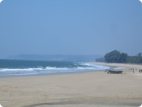
GUHAGAR BEACH
GPS COORDINATES ( CENTRE POINT OF BEACH) (17� 29' 36.00"N 73� 11' 03.00"E)
Open Map with Google Earth Please Note: Please install Google Earth before opening this file.
Approximate distance from Guhagar 0.0 kilometer. From small village called Asgoli (south beach end) to an area called Baug (north beach end) Guhagar beach is spread 6 kilometer. This happens to be major attraction for all the tourist. Breathtakingly beautiful!
Please keep this virgin beach clean and safe ( Be a responsible tourist. Don�t throw plastic bags, glass bottles, disposable food plates on the beach. We will really appreciate your good behavior !) Of late bhelpuri-chat stalls and beach shacks have come up during high season.
BUDHAL BEACH
GPS COORDINATES (17� 24' 24.00"N 73� 10' 38.00"E)
Open Map with Google Earth Please Note: Please install Google Earth before opening this file.
Approximate distance from Guhagar 20.00 kilometer. Serene and virgin beach with yellowish sand. Budhal village is sparsly populated with only about 50 houses. To reach here take Guhagar-Hedvi road till Adur Phata ( About 5 kilomter from Adur Phata is Budhal beach). For more information Click Here. This 5 kilometer road is pretty bad. Don�t forget to get drinking water and food with you as there is no hotel close by. Very secluded beach. During high tide ( specially during rainy season ) its mesmerizing to see the clear waters as it gushes along the shore and hits the basalt rock formation along the shoreline. For more information Click Hrer. Try walking towards south hill range for about 500 meter. Breathtaking scene can be viewed from hilltop. For more information Click Here.
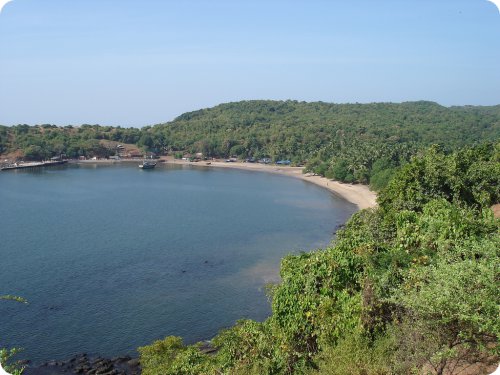
BORYA BUNDER ( BORYA PORT ) AND KARUL
GPS COORDINATES (17� 23' 10.50"N 73� 11' 25.50"E)
Open Map with Google Earth Please Note: Please install Google Earth before opening this file.
Approximate distance from Guhagar 22.00 kilometer. Borya bunder ( port ) is a typical tiny village. Karul is yet another small village very close by. Majority of local people are fisherman by profession. To reach here take Guhagar-Hedvi road till Adur Phata (About 6 kilomter from Adur Phata is Borya bunder). For more information Click Here. Those who are interested in burning extra calories , try walking towards Budhal beach along sealine. This walkway runs over a small hill which touches sea on west site. One can enjoy endless breathtaking sea view almost on three sides of this small hillock. For more information Click Here.
PALSHET BEACH
GPS COORDINATES (17� 26' 26.10"N 73� 11' 46.08"E)
Open Map with Google Earth Please Note: Please install Google Earth before opening this file.
Approximate distance from Guhagar 12.50 kilometer. Palshet is a small town on Guhagar- Hedvi road. For more information Click Here. Not many people know about this small beach. Beach side is a perfect place to spend one evening with family and friends. Recently archaeologist have discovered Waghbil cave or Musrundi cave , on Palshet to Pomendi road , 1 kilometer east of Barbhai, on the banks of a small perennial stream, near a waterfall, at a height of 85 m msl and 2 km inland first of its kind on Deccan plateau. On the basis of observations made on tool typology, geomorphology and lithostratigraphy, it is shown that early man occupied the cave during early Late Pleistocene. Also visit Chand Ghal near Narvan village. Get your scuba diving suits and explore ocean bed near Palshet beach. Manmade under ancient seawater wall has been recently discovered archaeologist. Only experienced scuba divers are advised to explore. One small jetty is at north end of Palshet beach. There is newly built road starting from this jetty and reaches south end of Guhagar beach ( Asgoli Village). This road is not asphalt ( tarr ) road and hence pretty bad for small sized cars. This 4 kilometer rout is good option for those willing to burn extra calories by simple walking. For more information Click Here.
TAVSAL BUNDER (TAVSAL PORT)
GPS COORDINATES (17� 17' 44.00"N 73� 14' 45.00"E)
Open Map with Google Earth Please Note: Please install Google Earth before opening this file.
Approximate distance from Guhagar 35.00 kilometer. Tavsal is a small port located on Tavsal creek. Tavsal is on one side of water channel and Jaygad is on the otherside of water channel. Visit Vijaygad ( a small fort) close to Tavsal. Don�t forget to visit Jaygad Fort. One has to take ferry service and cross water channel and reach Jaygad. One can also take leisurely boat ride around tavsal creek and if luck, spot the playful dolphins also. For leisurly boat ride and lunch-dinner call Mr. Jambharkar on mobile cell phone +91-9420052934 or +91-9421232214. Or call Mr. Vaibhav Surve on mobile cell phone +91-9869627033 .Click Here and Click Here to view road map.
VELNESHWAR BEACH
GPS COORDINATES (17° 22' 50.00"N 73° 12' 32.00"E)
Open Map with Google Earth Please Note: Please install Google Earth before opening this file.
Approximate distance from Guhagar 25.00 kilometer. This is yet another beautiful beach south of Guhagar. Dont forget to visit Velneshwar temple GPS COORDINATES (17�22'43.00"N 73�12'39.00"E ). Home cooked food is available in this small town. Don�t try to swim in this water. Never attempt to swim during low tide. It might be life threatening. Don�t forget to visit big farm house ( Nandan Agro Farms GPS COORDINATES 17�23'42.10"N 73�13'10.92"E ) at Velneshwar Phata. Narvan is one more small beach GPS COORDINATES (17�20'10.33"N 73�13'30.53"E)close by. This is the only beach in this region to have black sand on it. One more tourist attraction is Baman Ghal GPS COORDINATES (17�21'28.60"N 73�13'1.89"E ) or Open Map with Google Earth or Click Here on Hedvi beach. This beautiful natural wonder is a gorge ( narrow path) in the black rock patch and is around 20 feet deep, 35 feet long and 1-2 feet wide in dimensions. Only during the high tide, the sea water gushes in and splashes around. Also visit Uma Maheshwari Temple just before Baman Ghal. Don�t miss typical kokani food at Jivan Sugandh owned by Gokhale family ( For reservation call mobile cell phone +91-9764878116 or +91-9923404171 ) . Or simply feast on Suruchi Corner , an eatery close to Hedvi Beach. Those willing to walk ( about 5 kilometer ) visit Chandghal cave close to Narvan beach. This cave is about 3 kilometer long ( starts at beach and ends up high on close by hilltop) For more information Click Here. There are many beach cottages available around. Contact us for more information about different places to stay in.
VELDUR - DHOPAWE - DABHOL CREEK
GPS COORDINATES (of Dhopawe jetty) (17° 34' 47.80"N 73° 10' 54.71"E)
Open Map with Google Earth Please Note: Please install Google Earth before opening this file.
Approximate distance from Guhagar 12.5 kilometer. Veldur ( and Dhopawe) are on south side of water channel and Dabhol is on north side. Ferry service is available to cross the water channel (Between Dhopawe and Dabhol).Please note that there is no beach at any of these three places. Ferry service is available only during day time. Ferry service is closed during monsoon season. It is wonderful experience to load on your own vehical and cross water channel. Often dolphin fish can be seen crusing along water channel. Good place to spend lazy evening .Also visit Chandika Mandir ( about 10 kilometers from Dabhol ). Bharti shipyard Ltd are constructing giant ship building plant at Usgaon near Dabhol ( capacity to build Offshore Structures & ships upto 100,000 DWT. Interestingly this shipyard has massive 16000 ton floating dock ! ). Those interested in technological stuff must visit this place. Dont forget to watch sunset from Gopalgad (17� 34' 14.22"N 73� 9' 06.64"E) a fort nearby and a Tolekeshwar lighthouse ( Close to Anjanvel village) . After sunset , boat can be hired for private parties. Enroute Veldur, one can visit Mody Exotica, a big poly-house cultivating expensive orchids and Anthuriums. Just before Veldur one can see gas turbine based power plant ( Ratnagiri gas and power private limited or formerly known as Enron ) . For more informative map Click Here. For more information about Dhpave jetty Click Here.
DURGA DEVI MANDIR
GPS COORDINATES (17� 29' 41.40"N 73� 11' 17.00"E)
Open Map with Google Earth Please Note: Please install Google Earth before opening this file.
Approximate distance from Guhagar post office 1.5 kilometer. Durga devi is kulaswamini ( kuldaivat) of many people in India. Almost every hindu worships Durga devi. Recently a Bhakta Niwas ( Residential complex for devotees ) has been build along with newly constructed mandir. Some 15 separate rooms are available only for Devotee families. There is a medium sized man made pond next to mandir. During monsoon season its joyeous to enjoy swimming in this crystal clear water.
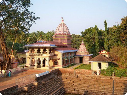
VYADESHWAR TEMPLE (LORD SHIVA)
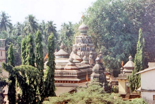
GPS COORDINATES (17° 29' 1.17"N 73° 11' 24.75"E)
Open Map with Google Earth Please Note: Please install Google Earth before opening this file.
This mandir is of Lord Shiv. Vyadeshwar happens to be ( kuldaivat) of many Chittapavan Kokanastha Brahmanfamilies. This ancient temple is at the heart of Guhagar town. There are many small temples ( like Lord Maruti ) on the premises. Vyadeshwar mandir trust offers accommodation to all devotees for couple of days stay.
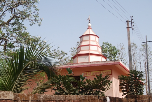
UFRATA GANAPATI MANDIR
GPS COORDINATES (17° 29' 13.00"N 73° 11' 19.60"E)
Open Map with Google Earth Please Note: Please install Google Earth before opening this file.
This mandir is one of its kind. Shree Murti is facing sea shore . i.e directing west. Normally its never like that. Normally it should face direction east. And hence name Ufrata ( reversed) Ganpati Mandir. There is a big entrance lobby. Good place to meditate and experience eternal bliss.
KOPRI NARAYAN MANDIR
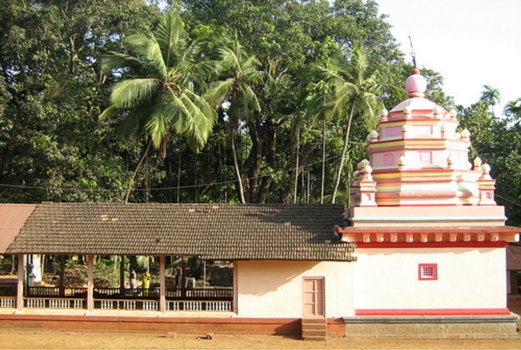
GPS COORDINATES (17° 29' 55.68"N 73° 11' 9.53"E)
Open Map with Google Earth Please Note: Please install Google Earth before opening this file.
Kopri Narayan Mandir is located in an area called varacha pat ( North Side ) of Guhagar. This mandir is of Lord Vishnu. There is one more temple of Lord Hanuman in the premises. Next to the Mandir there is an open air theatre. During festival season artists perform and act in play here. There is also a common community kitchen in the premises. Once a year ( Yearly utsav ) all the residents of Guhagar meet here and have lunch together. Every single woman of of every house prepares food. Its fun to watch enthusiasm of every single person involved. This also helps in uniting all the people to stand together. Very effective way to integrate community.
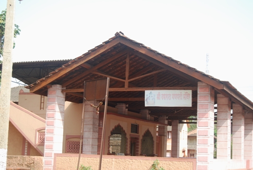
VYAGRAMBARI MANDIR
GPS COORDINATES (17° 29' 16.64"N 73° 11' 18.93"E)
Open Map with Google Earth Please Note: Please install Google Earth before opening this file.
This is � Gavdevi � of Guhagar town. There are many more mandir in Guhagar town like Shree Ganpati mandir at Asgoli village, Shree Dattamandir at khalcha pat (17° 30' 07.00"N 73° 11' 07.75"E) , one more mandir at Aregaon Village (17 30' 38.69"N 73° 11' 11.25"E)
ASHTAVNE PEAK (GANAPATI MANDIR)
GPS COORDINATES (17° 29' 56.97"N 73° 11' 19.45"E)
Open Map with Google Earth Please Note: Please install Google Earth before opening this file.
Approximate distance from Guhagar post office 2.5 kilometer. There is a small Shree Ganpati mandir at Asthavne Peak. There are 2 walkways to reach Astavne Peak. One starts from Kopri Narayan Mandir and second start from Durga Devi mandir.One has to climb about 150 meters ( One has to walk as there is no road reaching Astavne ). Also there is small fresh water stream close to mandir. This stream never drys up ( Not even during harsh summer months viz March , April May). Go here every alternate day. Best morning exercise to check how healthy are you. Those who have more engery can climb further 100 meters to reach hilltop ( Called Partavne). During rainy season lush green entire Guhagar town facing deep blue see can be seen from Partavne.
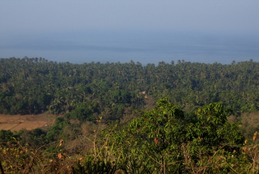
ASGOLI VILLAGE AND NEARBY SEA TOUCHING HILLSIDE
GPS COORDINATES (17° 27' 51.23"N 73° 11' 35.24"E)
Open Map with Google Earth Please Note: Please install Google Earth before opening this file.
Approximate distance from Guhagar post office 3.0 kilometer. Asgoli is small village at south beach end of Guhagar. For more information Click Here. Fishing is main activity done by majority of local people. One can buy the freshest fish here. Visit a farm house by Mr. Shah ( Can be rented on request). Walk about 350 meters south to reach Sunset point. This point is pretty secluded place. Dont forget to get battery operated torch as there are no street lights in this area.
It will be pitch dark after Sun set. Recently there is a road being build up connecting Asgoli to Palshet ( Still under constriction. Please note that this is pretty bad road. This is not asphalt road). This road runs over hilly region. Spectacular view of endless blue sea merging into the sky, Guhagar beach , lush green ladscapes etc etc can be seen from many places on this hilly region.
( Just walk towards sea and experiance yourself). A must see for those interested in Nature Photography ! Buy Sukad ( dried fish ) from Asgoli fish market.
EMU BIRD FARM AT DEVPAT
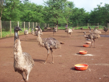
GPS COORDINATES (17° 29' 22.40"N 73° 11' 15.00"E)
Open Map with Google Earth Please Note: Please install Google Earth before opening this file.
Approximate distance from Guhagar 0.8 kilometer. Emu is a name of this bird. Emu flesh is very healthy to eat. It has 98 % fatty portion with least cholesterol and high percentage of iron in it. Fix an appointment with Mr.Ashik Devkar +91-2359-240705 to visit this place. Visit www.simranemufarm.com
BOAT CLUB, PATPANHALE LAKE
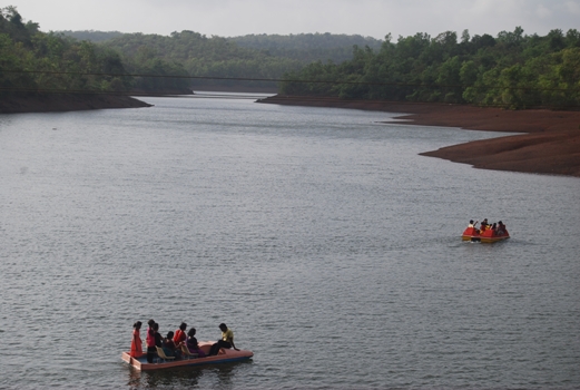
GPS COORDINATES (17° 28' 52.70"N 73° 13' 10.50"E)
Open Map with Google Earth Please Note: Please install Google Earth before opening this file.
This boat club ( Vishal Boat Club) offers peddle boat rides. One boat can carry 5 to 6 people. Also visit Dam ( cement wall Click Here to view a map ) by which this water has been retained. Our office GUHAGAR TOURISM DEVELOPMENT COMPANY at BRAKE MOTOR HOUSE is very close from boat club.This is good place to spend one lazy evening. Only expert swimmers are advised to swim here under supervision ( Beware of Masrshy - mud soil below water. Also there are many water snakes in this water). Visit Khatu Masale Udyog ( Spices manufacturing factory by Mr.Khatu) close by.
MODY ORCHID AND ANTHURIUM FARM
GPS COORDINATES (17° 31' 34.00"N 73° 10' 49.00"E)
Open Map with Google Earth Please Note: Please install Google Earth before opening this file.
Approximate distance from Guhagar post office7.5 kilometer. Mody farm is one major tourist attraction in Guhagar. Farm is located on Guhagar � Veldur road. Over 21 varieties of Cut Anthuriums, 9 varieties of Pot Anthuriums and 5 varieties of Potted Anthuriusm and 3 varieties of Orchids Dendrobium plant are cultivated here. Spread over about 15 acres of land, a multi million rupees project by Mr.Mody this is a must see to everyone. Also visit Gopalgad fort, light house at village Anjanvel, Ratnagiri Gas Power Plant ( Formerly know as Enron Plant ), Veldur-Dhopave-Dabhol creek, Bharti Shipyard at Usgaon ( close to dabhol).
(Chandika Devi mandir GPS COORDINATES 17° 35' 44"N 73° 10'52"E ). All these places are close by ( About 5 kilometer from Mody Farm).For more information Click Here.
GOPALGADH AND NEARBY LIGHT HOUSE
GPS COORDINATES (17° 34' 14.22"N 73° 09' 06.64"E)
Open Map with Google Earth Please Note: Please install Google Earth before opening this file.
Approximate distance from Guhagar post office 14.0 kilometer. One has to pass through Ratnagiri Gas power plant premises to reach Anjanvel and then travel towards Gopalgad. Car can reach right till entrance gate of Gopalgad. This ancient fort is believed to be built at the start of 16th Century by the Siddis. It was captured by Shivaji Maharaj in 1660. What remains today is only the ruins of this huge fort that spans 7 Acres of land. The lighthouse GPS COORDINATES (17° 33' 56.49"N 73° 08' 28.58"E) is about 1.7 kilometers south from Gopalgad. Tolekeshwar mandir is at the entrance of the lighthouse premises. This entire area is located on small hill and hence it is always very windy. Specially during rainy season ( 15 June to 15 September ) one can view beautiful lush green landscapes around. Surrounded by the Sea on all three sides , Gopaldag and creek next to it offers picturesque scenery. Spend an evening followed by dinner and campfire. A perfect place for all nature lovers. Don�t forget to get packed food and drinking water as there are no restaurants or hotels close by. Also visit Dhopave Jetty and Veldur creek and Dabhol Jetty. For more information about Gopalgad Click Here. For more information about Light house Click Here
MUSRUNDI CAVE AND UNDER SEA WATER WALL AT PALSHET
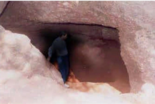
Just Before Palshet take a left turn towards Pomendi , this cave is located 1 kilometer east of Barbhai ( On Palshet-Pomendi road ). Proof of 90000 old civilisation are found here. Tools used by prehistoric mankind are found here. This place was discovered by archeoligist Mr. Marathe of Deccan college , Pune. For more information Click Here. Local people call this place as Tiger den ( Waghbil in Marathi language ).
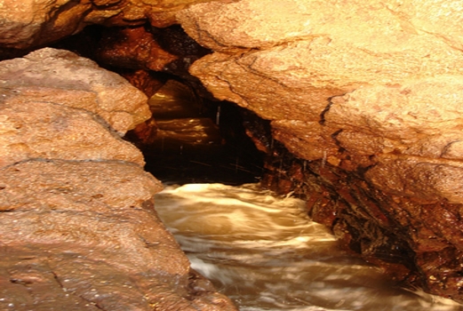
BAMAN GHAL (GORGE) AT HEDVI BEACH
GPS COORDINATES (17° 21' 28.60"N 73° 13' 1.89"E)
Open Map with Google Earth Please Note: Please install Google Earth before opening this file.
Approximate distance from Guhagar 29.0 kilometer. Baman Ghal is situated on Hedvi beach. Baman Ghal is unique landscape in its own way. This beautiful natural wonder is a gorge in the black rock patch and is around 20 feet deep, 35 feet long and 1-2 feet wide in dimensions. During the high tide, the sea water gushes in and splashes around. Its fun to watch this wonder. Also visit Dashabhuja shree Ganpati Mandir GPS COORDINATES (17�21'17."N 73�13'57.50"E ) to see a road map Click Here at Hedvi .For more information Click Here.
DASHABHUJA SHREE GANAPATI MANDIR AT HEDVI
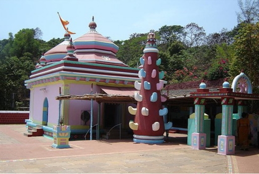
GPS COORDINATES (17° 21' 17.00"N 73° 13' 57.50"E)
Open Map with Google Earth Please Note: Please install Google Earth before opening this file.
Approximate distance from Guhagar 29.0 kilometer. At Hedvi the most famous is the temple of Dashabhuja (10 Hands) Ganapati. This temple dates back to age of Peshwas ( King of Maharastra, post Shivaji dynasty). The idol of lord Ganesha is carved in marble and is supposed to be from Jammu-Kashmir. The temple is recently renovated and is very clean and simple. Do not forget to visit Bamanghal GPS COORDINATES (17�21'28.60"N 73�13'1.89"E ) or Open this file using Google Earth during high tide on Hedvi beach. For more information Click Here. Hotel Devrai offers accommodation and delicious pure vegetarian food ( for reservation call Mr. Joglekar +91-2359-243720 or +91-2359-225 ) . There is one more good restaurant called Suruchi Corner in Hedvi ( For reservation call Mr. on +91-2359-243208 or mobile cell phone +91-9421714961 )
CHAND GHAL (BROAD GORGE) AT NARVAN BEACH
Approximate distance from Guhagar 29.0 kilometer. At Hedvi the most famous is the temple of Dashabhuja (10 Hands) Ganapati. This temple dates back to age of Peshwas ( King of Maharastra, post Shivaji dynasty). The idol of lord Ganesha is carved in marble and is supposed to be from Jammu-Kashmir. The temple is recently renovated and is very clean and simple. Do not forget to visit Bamanghal GPS COORDINATES (17�21'28.60"N 73�13'1.89"E ) or Open this file using Google Earth during high tide on Hedvi beach. For more information Click Here. Hotel Devrai offers accommodation and delicious pure vegetarian food ( for reservation call Mr. Bhatkar +91-2359-243208 or mobile phone: +91-9421714961 ) . There is one more good restaurant called Suruchi Corner in Hedvi ( For reservation call Mr. on +91-2359-243208 or mobile cell phone +91-9421714961 )
VIJAYGAD AND TAVSAL CREEK AND JAYGAD
GPS COORDINATES ( Of Tavsal Jetty ) (17° 17' 44.00"N 73° 14' 45.00"E)
Open Map with Google Earth Please Note: Please install Google Earth before opening this file.
Approximate distance from Guhagar 35.0 kilometer. Tavsal is a small port located on Tavsal creek. Tavsal is on north side of water channel and Jaygad is on the south of water channel. Visit Vijaygad ( ruined remains of erstwhile fort) just before reaching Tavsal. One has to take ferry service and cross water channel and reach Jaygad. One can also take leisurly boat ride around Tavsal creek and if luck, spot the playful dolphins also. For leisurely boat ride and lunch-dinner call Mr. Jambharkar on mobile cell phone +91-9420052934 or +91-9421232214. Or call Mr. Vaibhav Surve on mobile cell phone +91-9869627033 . To cross this creek by car ,one has to reach Bhatgaon � Rai bridge ( click here to see a road map ) GPS COORDINATES (17° 12' 41.73"N 73° 24' 55.90"E). After crossing this bridge this road further goes to places like Ganpatipule , Ratnagiri city, Pawas, Hatkhamba, Mumbai to Goa National Highway Number 17 etc etc .For more information Click Here and Click Here
PETHE BRAKE MOTOR PVT. LTD.
Pethe brake motor private limited, Modkaghar, 02359-240297, www.pethe.in GPS coordinates (17� 28' 45.50"N 73� 13' 05.50"E)
Open Map with Google Earth Please Note: Please install Google Earth before opening this file.
Approximate distance from Guhagar post office 4.0 kilometer. Firstever industrial manufacturing plant of this area. Founded in 1982 by Mr. Bhalchandra Waman Pethe. About 67 people work in this 15000 sq.feet plant equipped with modern high-tech machines like CNC turning centre, Traub automat, vertical milling machine, cylindrical grinder etc etc. A must see for all those wishing to become entrepreneurs or planning to setup own business. Administrative office of GUHAGAR TOURISM DEVELOPMENT COMPANY is in this premises. To fix factory visit call Mr.R.S.Kanitkar ( Manager ) on +91-2359-205142 or Mr.S.M.Athavle ( Store Manager) +91-2359-205163 . For more information Click Here.
They have one more manufacturing plant at Lonavla and own one of the most trusted jewellery retail shops in India named Waman Hari Pethe Saraf , Mumbai. For more information visit www.pethe.in
KHATU MASALE UDYOG
Khatu Masale udyog, Patpanhale, 02359-244329, GPS coordinates (17� 29' 10"N 73� 13' 35"E)
Open Map with Google Earth Please Note: Please install Google Earth before opening this file.
Approximate distance from Guhagar 5.5 kilometer. Founded by Mr.Khatu , Khatu Masale is of the most popular spice brand here. You can actually see manufacturing process of all the spices you use like chili powder, turmeric powder, biryani masala and much more. You can be assured to find one of the finest quality of spices here. Its good idea to buy all the spices you need for next whole year. To fix a factory visit call +91-2359-244329 ( Please inform number of visitors and do inform them that you came to know about their spice factory through www.guhagar.com .You will get priority in visitors waiting list. ) For more information Click Here.
Number of Visits
GUHAGAR TOURISM DEVELOPMENT COMPANY
Pethe Brake Motor Complex, 564-A Modkaghar, village Varveli, Guhagar , Maharastra India Pincode - 415703
FOR BOOKING AND GENERAL ENQUIRY CALL MR. VIKRAM KHARE +91-7776097557
Tel +91-2359-240216 , Fax +91-2359-240529 , guhagartourism@gmail.com www.guhagar.com
Copyright © 2010 All Rights Reserved by PETHE BRAKE MOTOR PRIVATE LIMITED
Designed & Maintained by

This website is sponsored by WAMAN HARI PETHE SARAF , Girgaum Mumbai
Best Viewed in Internet Explorer 7.0 and above. Resolution "1280 x 800."